The River Arts District experiences flood water from time to time… below are some links to help see what is predicted or currently happening.
NATIONAL WEATHER SERVICE : FRENCH BROAD RIVER @ ASHEVILLE GAUGE
FRENCH BROAD RIVER @ ASHEVILLE GAUGE IN FIMAN This gauge is next to the Pearson Street Bridge right behind French Broad Outfitters!
FIMAN / NC : FLOOD INUNDATION MAPPING AND ALERT NETWORK
EAST WEST ASHEVILLE RAIN GAUGE @ WUNDERGROUND.COM
The French Broad River @ Asheville Gauge (FBR@AVLG) is slightly delayed but real time #s of the current height of the French Broad River @ the Pearson Street Bridge about a mile north of Smokey Park Supper Club, behind French Broad Outfitters. This gauge also shows predictions for how high the French Broad River is predicted to get 24 hours in the future. These predictions are never correct. Sometimes they under estimate and sometimes they over estimate. They also change fast. But by watching all these various gauges, days prior to a predicted event and seeing how they are trending…. and knowing what i have seen in the past 15 years helps me to have some sense of when i need to be scared and when i can just be vigilant. With practice, you can do this too!
On Good Friday in 2019, @ 9am, a 6.5 feet crest was predicted on the FBR@AVLG… by noon the prediction had raised to 9.5 feet and raised again up to 12.5 feet @ 2pm…. the river crested @ 11.3 feet @ 10:45 pm… a few inches shy of putting water on the first floor of #7 CURVE studios. (see photo below that shows about 10 feet on Lyman just south of the roundabout) This also probably just missed putting water in some of the downstairs spaces @ Riverview Station. This one was an outlier for me… The prediction of 5 inches of rain did not concern me… The last big one in the RAD was from Hurricane Francis in 2004 was a total rain fall of 17 inches, which ended up, by the current gauge reading, @ 15.55 feet.
The Good Friday event came up so fast with very little warning and was only about 5 inches of rain. My take away from that one is that the factors, that effect when the French Broad floods, are changing. Any prediction of over 10” has me worried, as with Hurricane Florence in 2018. While this Hurricane did immense damage in the eastern part of the state, it tracked enough east of us to bring only 2 to 3 inches of rain in Asheville. CURVE had packed up all it first floor belongings into trucks, ready to roll out if need be but we just turned right around and put everything back. Happily i might add. Another tidbit : most but not all of our flood events are rain from Hurricanes and Hurricanes rotate counter clockwise… the heaviest rainfall is always on the east side of the eye of a hurricane… so where it is tracking matters… if the eye goes a bit to our east, we will get less rain than if it tracks a bit to our west.

All of this to say that we never really “know” what will happen… so here are a couple of rules of thumb that i have witnessed over the years :
if the FBR@AVLG says:
6.5 feet… Riverside Drive under the railroad trestle is probably closed. if it says 8.5 feet, the sections of Lyman Street that used to be under water are now not! thanks to the RAD TIP. if it says 10 feet there is a good chance there may be standing water in the Wedge Foundation parking lot. if it says 12 feet there will be standing water inside buildings @ CURVE and Riverview Station. if it gets to 16 feet there probably will be water on the 1st floor of the Historic Cotton Mill Studios. one thing to note : in 2008 this flood gauge was recalibrated, so the 14.55 feet Flood level noted for the 2004 Hurricane Francis is now 15.55 feet. (you can see historic crests on the FBR@AVLG link)
also : the above photo shows the north end of Lyman street @ around 10 feet in 2019 which shut down the road… but since this section of roadway a la RAD TIP has been elevated / completed, we do not yet have first hand information (thank goodness) of what river level will close this road now? so i will update this page if and when we do.
FIMAN / NC system : you can sign up for alerts about river levels on this link as well as get the best real time data of what the current weather patterns are doing all over the state. This is a fine grain look at where a storm is tracking in real time and where river levels are rising and falling all over the state… I used this site alot to track Hurricane Florence in 2018 and found it very useful!
NOAA HURRICANE : this link helps to watch how hurricanes are predicted to move well in advance... i use the 5 day cone to see how a hurricane is tracking…this changes often so it is worth watching everyday to see which way the winds blow… literally… i also use the rain fall prediction cones to see how much rain we are predicted to have…
Lastly… flood waters that get into buildings have happened historically every 15 to 20 years. The last big one in the RAD was 2004. Stay Safe, do not drive thru standing water, take this seriously please… stay in touch!
This section was written by Pattiy Torno, with 33 years worth of owning CURVE studios and being a student of the French Broad River after Hurricane Francis put 4 feet of water on the CURVE property. That’s her standing in those flood waters below!
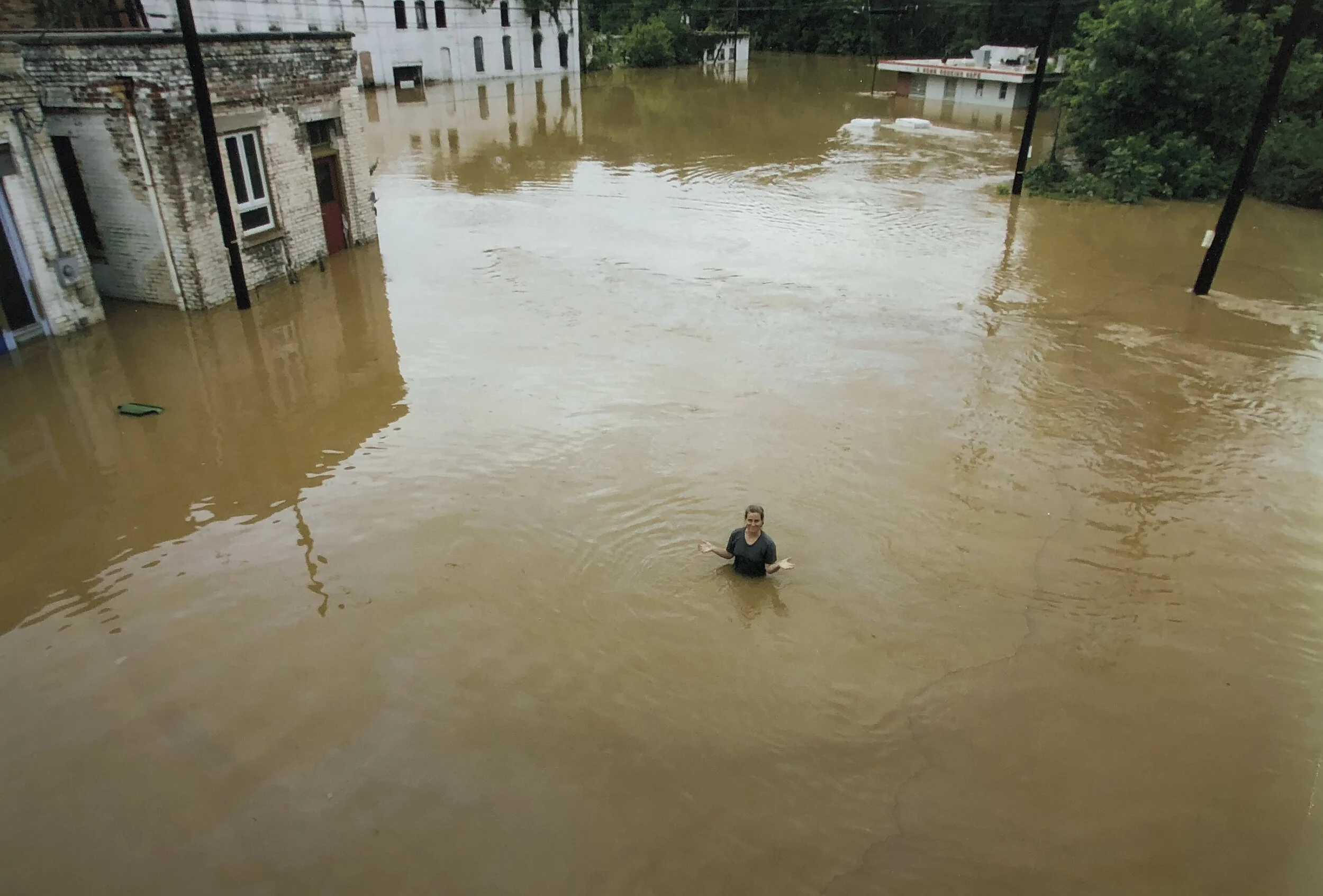
Pattiy standing in the parking lot of CURVE studios @ high water on Wednesday September 8, 2004

the smoke stack you see with smoke was just north of what is now CURVE studios… this would be equivalent to a 2020 flood level of around 24.1 feet.. the small white wave line next to the door of RiverLink shows this same 1916 flood level on the building itself!